
Historians from Bialystok have found in Paris an unusual map of the Republic from the 17th century.
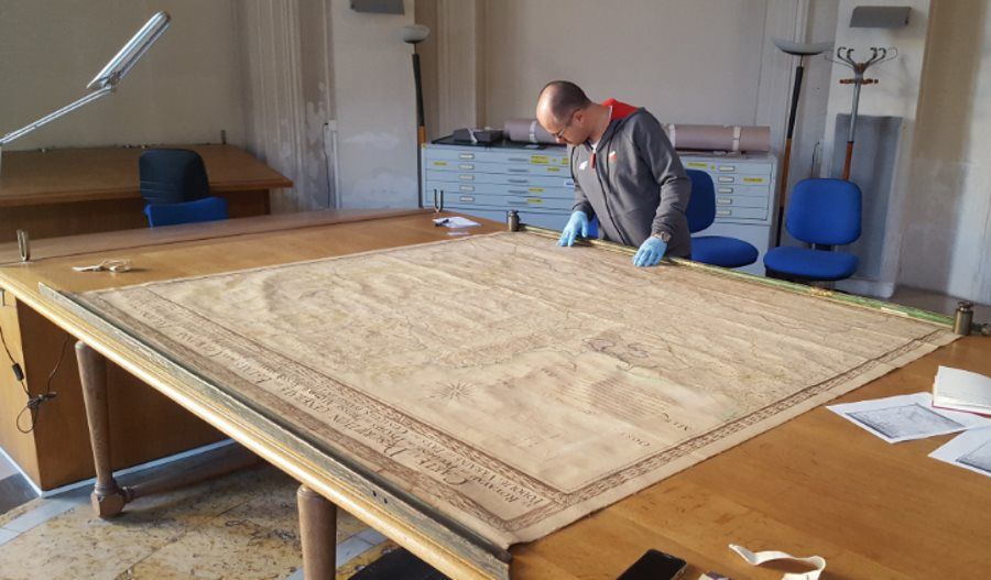
Historians from the University of Bialystok have found in the French National Archives an unusual manuscript map of the Republic dating back to the second half of the 17th century. The map measures – 198 by 183 cm, and the area covered is presented at a scale of approx. 1 to 880,000.
Bialystok historians – Dr. Wojciech Walczak and Dr. hab. Karol Lopatecki – They came across the clue of the previously unknown map in 2016, while researching the manuscriptoIn the castle of the Condeuses in Chantilly, France. Scientist studied the works of the prominent 17th century geographer and cartographer Guillaume Sanson, ktore contain descriptions of the areaoin belonging to the republic.
– It was a geographic description of the lands of Poland and Lithuania made by Sanson, along with maps of the detailedolithuanian lands of the republic. It contained the characteristics of these areasow, as well as a very extensive index of localities with the given wspogeographic coordinates. This work was based primarily on information compiled earlier by another cartographer, Guillaume’a de Vasseur Beauplan, but contains additional objects thatore uszczegoThey paint a picture of the Republic of Poland – explained Dr. Wojciech Walczak quoted in a communiqué published on the website of the University of Bialystok (UwB).
Based on these analyses, the researchers concluded that there must have been a manuscript general map of the Republic rodiffering from other known versions. And it was this map that they managed to find in Paris at the French National Archives. As UwB researchers were able to determine, the map was drawn up by the aforementioned Sanson at the request of the princes of Condé.
The large-format, hand-drawn map is titled: CARTE ET DESCRIPTION GÉNÉRALE DES ESTATS DE LA COURONNE DE POLOGNE OÙ SONT LE ROYAUME DE POLOGNE, LES DUCHÉS DE PRUSSE, MAZOVIE, RUSSIE NOIRE, LE GRAND DUCHÉ DE LITHUANIE, LES PROVINCES DE VOLHYNIE, PODOLIE, UKRAINE OU PAYS DES COSAQUES, DIVISÉS EN LEURS PALATINATS, SUBDIVISÉS EN CHASTELLENIES (Map and general description of the lands of the Republic, showing the KroThe Polish principality, the Duchy of Prussia, Mazovia, Ruthenia, the Grand Duchy of Lithuania, Volhynia, Podolia, Ukraine and the Cossack lands, divided into provincesodztwa with marked castellanies).
The map is in good condition, even the original spar with fragments of gilding and a fragment of the wooden frame have been preserved, in ktorej was framed – reads the announcement on UwB’s website. Guillaume Sanson prepared it on the basis of a detailedoThe works of his father Nicolas, whoory is called „father of french cartography”.
As the researchers recall, as early as 1660. The idea of selecting a new krola during the ruler’s lifetime (vivente rege election). The researchers indicate that the candidate supported by John Casimir Vasa was the son of Louis Bourbon, known as the Grand Condeus (1621-1686) – Henri Julius de Bourbon (1643-1709), Prince de Condé. These plans were not realized, but another opportunity came after the death of John III Sobieski. WoAt the time the candidacy of Francis Louis Bourbon-Conti was put forward, ktory was a nephew of the Grand Condeus.
– The creation of the description and map of the lands of the Crown and Grand Duchy of Lithuania should be associated with these figures. In preparation for the exercise of power in the Republic, he was supposed to helpoc particularolows geographical description of the lands of Poland and Lithuania. The task fell to both Sansons. Neither Henry Julius de Bourbon nor François Louis de Bourbon-Conti assumed the Polish throne, so also the resulting work was never published in print. Fortunately, two manuscript copies of the atlas preserved in the Château de Chantilly Library and Archives, stressed Dr. hab. Karol Lopatecki.
The research conducted by UwB scholars on manuscript maps of the Republic has been ongoing since 2008 and is being carried out as part of an international project headed by Dr. Wojciech Walczak of UwB and prof. Andrew Pernala of the University of Calgary. The team also includes Dr. hab. Mariusz Drozdowski (UwB) and Dennis F. Essar of the University of Edmonton (Canada). The venture was supported by the Polonica Institute.
A publication containing a translation of the description of the lands of the Commonwealth along with Sanson’s maps will be released in 2019.
Sourceobackground: the University of Bialystok, PAP, fot. Private archive of dr. Wojciech Walczak